What is a Watershed?
A watershed is an area of land that feeds all the water running under it and draining off of it into a body of water. It combines with other watersheds to form a network of rivers and streams that progressively drain into larger water areas.
Topography determines where and how water flows. Ridge tops surrounding a body of water determine the boundary of a watershed. Imagine turning an open umbrella upside down in the rain. The rain that hits anywhere within the umbrella’s surface area would go to the bottom at the center of the umbrella. Any rain that didn’t hit the umbrella would fall to the ground. The umbrella is like a watershed; it collects everything that falls into it.
Waterways within the watershed all feed into that main body of water, which could be a river, lake, or stream. The beginnings of a water source are called headwaters. The spot where headwaters progressively join other water sources is called the confluence, and the endpoint of the waterways that open into the main body of water is called the mouth (source: Environmental Protection Agency).
To return to the umbrella example, imagine now that there are three groups of umbrellas. One group of large umbrellas (the basin) sits on the ground, while another group of smaller umbrellas (watersheds) floats above them, with a hole in the bottom of each. Yet another group of even smaller umbrellas (catchments) floats above those, also with a hole in the bottom of each. If the rain was caught in the top level of umbrellas, it would drain into the larger umbrellas below, which would drain into the largest umbrellas below them.
Of course, this is a simple model. Water does not simply hit the land and roll off it into a stream. Rainwater (and everything else) is lost through absorption by plants, evaporation, and consumption by humans. These factors also depend on the area; the clay-like soil of Georgia will not absorb as much water as the loose soil of Kansas.
So, why do watersheds matter? Why is it imperative that they stay healthy?
Watersheds directly affect water quality, whether it’s for drinking or recreation. For example, algae bloom from fertilizer runoff draining into water harm watershed health, as does mercury and lead seeping into the water supply due to pollution. As states and cities try to find new sources of uncontaminated drinking water, keeping watersheds healthy becomes increasingly vital to finding clean water [source: Environmental Protection Agency].
Unhealthy watersheds affect wildlife. The polluted water supply that results can become harmful to humans. Aquatic life quickly suffers the effects of watershed pollution, while new pollutants introduced into ecosystems alter wildlife habitats. This reduces biodiversity by eliminating some species and introducing new, invasive ones that destroy the native species. That, in turn, can affect the food chain, from microbial organisms that feed birds and animals to fish that feed humans.
According to the EPA paper “Sustaining Healthy Freshwater Ecosystems,” one freshwater ecosystem can be greatly affected by another: “Far from being isolated bodies or conduits, freshwater ecosystems are tightly linked to the watersheds or catchments of which each is a part, and they are greatly influenced by human uses or modifications of land as well as water” [source: Environmental Protection Agency].
The threat of erosion also exists. Water flowing to a stream picks up dirt along the way. If the water picks up enough soil over time, the land along that stream will become unstable and eventually erode away. If you live along a river bank, this could mean losing your backyard. For wildlife that lives in this area, it means a loss of their habitat.
The sharp increase in development around the world may contribute to some of the problems affecting watersheds today. Development in the Amazon Basin has threatened the Amazon river dolphin with extinction [source: Water Resources eAtlas]. Urban development often involves removing plants, artificially changing the surface topography and altering naturally formed drainage networks. All of these factors affect an area’s watershed. In addition, manmade land covers, such as asphalt roads or buildings, act as what the United States Geological Survey calls a “fast lane” for rainfall. Rainwater that would have been absorbed by soil and plants instead is sent directly into streams. These fast lanes increase the chances for flooding because more water pools in that area than a stream can hold [source: U.S. Geological Survey].
The Molalla River Watershed
Geology
The headwaters of the South Fork and the Table Rock Fork are basalts older than the Columbian basalts. They are part of the Sardine series volcanic. As the two rivers forks join to form the main stem of the Molalla River, they begin cutting into the Stayton lavas. The basalts form narrow canyons where column rosettes and defined basalt columns can be seen mostly on the east side of the river.
The west side of the river has an overlying layer of the Molalla formation. Carbon dating of fossil leaves, which are abundant in this area, has placed it in the upper Miocene period. The river cuts deeply into this formation creating narrow canyons and beautiful rock outcrops.
Want to learn more about the Geology of the Molalla Recreation Corridor? Local geologist and long-time friend of the Molalla River, Bob Oblack, will take you on a very informative tour of the geologic formations of the Molalla Recreation Corridor. Check out the video to the right. In the second video to the right, Sheila Alfsen, professor of geology at Portland State University, and Bob trace the Ginkgo lava flow from Molalla to Newport that formed our area. You can even learn about Jory soil, Oregon’s State Soil.

History
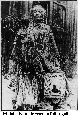
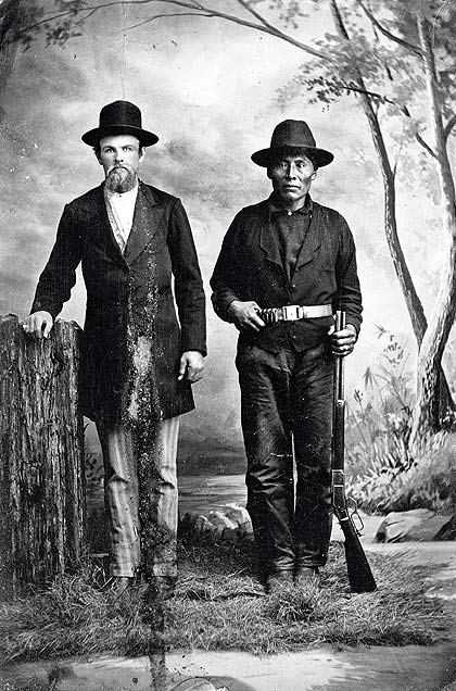
In pre-historic times, an extensive system of trails existed along the Molalla River. These trails provided a trade route between peoples of the Willamette Valley and those of Eastern Oregon. During the early 19th century, the area around the river was populated by the Molala people. The Molala (also Molale, Molalla, Molele) were a people of the Plateau culture area in central Oregon, United States. They are one of the Confederated Tribes of the Grand Ronde Community of Oregon, with 141 of the 882 members in the 1950s claiming Molala descent.
The Molalla Native Americans used one such trail in the early 1800s. It is now called the Table Rock Historic Trail.
During the 1920s this same trail was utilized by Native Americans from the Warm Springs Reservation to reach traditional huckleberry picking areas near the Molalla River and Table Rock.
Starting in about 1840, European-American settlers began farming in the bottomlands along the lower Molalla. Spurred by the passage of the Donation Land Claim Act, the influx continued, and by 1860 there were 75 households in the Molalla area. Wheat was the most common crop, and these early settlers also cultivated potatoes and root vegetables such as turnips and cabbages and planted apple trees. They fished, hunted, gathered huckleberries, and kept sheep, cows, pigs, and chickens.
Gold mining occurred along the Molalla after the discovery of placer gold in 1860. Many claims were filed during the next 40 years. Four mining companies, of which the Ogle Mountain Mining Company was the biggest, had operations in the watershed by the early 20th century. The company operated a mine along Ogle Creek, a Molalla tributary, between 1903 and 1915.
In the 20th century, the watershed became an area of intense logging. Timber companies built forest roads and a spur railroad, set up timber camps, constructed splash dams, and used the river and Milk Creek for transporting logs. Between 1941 and 1945, hundreds of log trucks passed through Molalla every day.
Today, logging and recreational use are the primary activities in the upper reaches of the Molalla River.
Landowner Resources
WILDFIRE RESOURCES: Pointing you in the right direction towards recovering from the 2020 Wildfires
Local Resources Covering a Variety of Fire-Related Topics
- Clackamas Soil & Water Conservation District, 2020 Wildfire Resources
- Willamette Partnership, Oregon Wildfire Recover Resources & Contacts
- Clackamas County, Wildfires 2020
- City of Molalla, Wildfires 2020: Updates, Resources, and Information
- State of Oregon, 2020 Oregon Wildfire Response and Recovery
- OSU Forestry & Natural Resources Extension Fire Program
- OSU Extension Fire Program Online Webinar Classes
- American Red Cross, Western Wildfires: Cascades Region
- Oregon Department of Forestry, Help After a Wildfire
- Oregon Department of Agriculture, Wildfire Resources
- Oregon Department of Agriculture, Animal Health & Livestock Identification Fire Response Tracing 2020
- Video on How to Make a Box Fan Filter, A DIY User’s Guide to Protecting Your Home from Wildfire Smoke, Colville Tribes Air Quality Program
- Oregon Department of Environmental Quality Wildfire Response
Fire-Related Technical &/or Financial Assistance Program Contacts
- US Department of Agriculture, Natural Resource Conservation Service (bottom of webpage has several fact sheets for post-fire tools)
- Oregon City Service Center, 503-655-3144 Ext 108, Kimberly Galland Kimberly.Galland@usda.gov
- US Department of Agriculture, Farm Service Agency
- Recovery Programs for crops, pastures, orchards, nurseries, livestock
- Oregon City Service Center, 503-655-3144, Darca Glasgow darca.glasgow@or.usda.gov
- Oregon Department of Forestry
- North Cascade District, 503-829-2216, Stewardship Forester Mike Haasken
- Oregon State University Extension Service, Forestry & Natural Resources Extension
- Fire Program Manager, Carrie Berger
- Clackamas County Office in Oregon City, 503-655-8631
- Clackamas Soil & Water Conservation District
- 503-210-6000
News Releases
- New Collaboration Between Natural Resources Conservation Service (NRCS) and FEMA to Provide Disaster Recovery Assistance (Sep 22, 2020)
- City of Molalla, Drinking Water Quality Update – Sep 18, 2020
- Oregon Humane Society Response Update: 2020 Oregon Wildfires – Sep 9,2020
List of Consultants for the Oregon Forestry Sector
Lessons Learned from 2020 Fire Evacuations
- Sign up with Clackamas County for their Public Alert Notification System to receive emergency messages via email, phone call, and text.
- Evacuation
- Green Level 1: BE READY for Potential Evacuation. Residents should be aware of the danger that exists in their area, monitor emergency services websites and local media outlets for information. This is the time for preparation and precautionary movement of persons with special needs, mobile property and (under certain circumstances) pets and livestock. If conditions worsen, emergency services personnel may contact you via an emergency notification system.
- Yellow Level 2: GET SET to Evacuate. You must prepare to leave at a moment’s notice. This level indicates there is significant danger to your area, and residents should either voluntarily relocate to a shelter or with family and friends outside of the affected area, or if choosing to remain, to be ready to evacuate at a moment’s notice. Residents MAY have time to gather necessary items, but doing so is at their own risk. This may be the only notice you receive. Emergency services cannot guarantee that they will be able to notify you if conditions rapidly deteriorate. Area media services will be asked to broadcast periodic updates.
- Red Level 3: GO!!! Evacuate now! Leave immediately! Danger to your area is current or imminent, and you should evacuate immediately. If you choose to ignore this advisement, you must understand that emergency services may not be available to assist you further. DO NOT delay leaving to gather any belongings or make efforts to protect your home. This will be the last notice you receive.
- Oregon Department of Transportation TripCheck shows road conditions and closures.
- On Facebook, follow the Clackamas County Sheriff’s Office for updates on evacuation status & daily fire briefings.
- Follow near real-time active fire data using the Fire Information for Resource Management System (FIRMS) Fire Map. If you click on the “Advanced” Tab, you can change the range of days you want to see data from.
- InciWeb – Incident Information System is an interagency all-risk incident information management system that provides the public with a single source of incident related information.
- Sign up to receive emails from Clackamas County by going to their website, you have to scroll to the very bottom, below the “can’t find what you’re looking for?” is Get email updates. Click on Get email updates.
During a public meeting on Sep 23, 2020 with the Clackamas County Commissioners “Listening Session: Wildfire Recovery”, they really emphasized emailing eocpic@clackamas.us with any questions.
Clackamas Soil & Water Conservation District
District employees work with landowners to meet natural resource conservation goals. Their top three concerns are water, weeds, and wildlife.
(503) 210-6000
Oregon State University Extension Services, Clackamas County
Extension educators work with OSU scientists to teach community members through programs and research-based learning materials. Topics include environment, trees & woodlands, gardening, small farms, food preservation, food & nutrition, family & youth, and health & wellness. At the bottom of their homepage, there is an “Ask an Expert” button!
(503) 655-8631
Bureau of Land Management (BLM)
The BLM works to manage and conserve the public lands for the use and enjoyment of present and future generations, including the Molalla River Recreation Corridor and the Table Rock Wilderness Area.
(503) 375-5646
Oregon Department of Fish & Wildlife (ODFW)
ODFW provides information on Oregon fishing, hunting, wildlife, licenses and regulations, and conservation.
(503) 947-6000 or (800) 720-ODFW [6339]
Natural Resources Conservation Service (NRCS)
NRCS is part of the U.S. Department of Agriculture and they provide farmer, ranchers, and forest landowners with financial and technical assistance to make conservation improvements to their land. For example, they might be able to assist you in your effort to provide nectar, pollen, and larval food sources for pollinators on your farm.
(503) 655-3144 ext. 108
Current Discharge Conditions for U.S. Geological Survey Gage on the Molalla River near Canby
Graph of current discharge and gage height for the Molalla River near Canby, Oregon. The page is interactive and you can look at data over different time intervals.
U.S. Geological Survey Oregon Water Science Center
Data on surface water, groundwater, and water quality in Oregon and the rest of the U.S.
National Integrated Drought Information System (NIDIS), U.S. Drought Portal
A warehouse of drought-related issues such as information on managing impacts of drought, and past and current drought conditions. Under regional programs, Pacific Northwest, there are lots of really interesting maps showing current conditions, water supply, impacts, and looking ahead.
WeedWise, Clackamas Soil & Water Conservation District
The WeedWise program serves as a technical resource to local landowners and land managers trying to control invasive weeds on their property.
(503) 210-6000
Oregon Invasive Species Online Hotline
Report potential invasive species or get help identifying something that could be an invasive species to help provide vital early detection information to the experts working to stop the next invasion before it starts.
SOLVE – Stop Oregon Litter and Vandalism
SOLV is a non-profit organization that organizes over 1,000 cleanup and restoration projects throughout Oregon. Molalla River Watch adopted 12 miles of the Molalla River in the Molalla River Corridor in 1992 through the SOLVe Adopt-A-River program and has been coordinating two annual river cleanups. SOLV conducts many native plant plantings each year and is involved in restoring public lands.
(503) 8440-9571 or (800) 333-SOLV [7658]
Dump Stoppers, Clackamas County
A program that is funded by a federal grant to deter illegal dumping and vandalism on U.S. Forest Service, Bureau of Land Management, and Clackamas County owned forest lands within the County. Call the telephone tip line when you see or suspect illegal dumping on federal, county, or timber company lands.
(503) 650-3333
Riparian Lands Tax Incentive Program
Landowners and the Oregon Department of Fish and Wildlife sign a riparian management plan and agreement to maintain, preserve, conserve, and rehabilitate riparian lands assuring protection of the soil, water, fish, and wildlife resources for the economic and social wellbeing of the state and its citizens. Landowners receive a complete property tax exemption for the riparian property up to 100′ from the stream.
Contact: Oregon Department of Fish and Wildlife (ODFW)
Patty Snow (503) 947-6089
The Xerces Society for Invertebrate Conservation
A non-profit organization for invertebrate conservation and its habitat. They offer a variety of publications to help identify and conserve invertebrates and manage their habitats. They also give workshops and presentations for growers on native pollinators.
(855) 232-663
Rodale’s Organic Life, Monthly Garden Calendar for the PNW
An organic gardening month by month almanac for the PNW.
Rainy Side Gardeners
Great gardening resource for the PNW. Check out the sections on native plants categories under the plant guides tab (http://www.rainyside.com/plant_gallery/natives/index.html) and native plants resources and links under the articles tab (resources for gardening with native plants, at bottom of articles, native plants page) (http://www.rainyside.com/resources/natives.html).
PlantNative
Information on native plants and landscaping resources to connect nursery owners, landscape professionals, and consumers.
Native Plant Society of Oregon
Native plant and habitat conservation group. Local chapters hold meetings, field trips, and plant shows and sales for members and non-members alike.
Northwest Edible Life: Life on Garden Time
Blog by “a professional chef turned gardening and urban homesteading fanatic” who lives in the Pacific Northwest. Posts include gardening, cooking, chicken and ducks, and food preservation.
National Pesticide Information Center
http://www.rainyside.com/resources/pesticide.html
Provides information about pesticides to help people make decisions about pesticides and their use. Run by Oregon State University and the U.S. Environmental Protection Agency.
(800) 858-7378 for questions about any pesticide-related topic (8am-12pm PST) or email npic@ace.orst.edu
Washington Department of Fish and Wildlife: Living With Wildlife
Information on how to make your backyard into habitat for wildlife includes landscaping design ideas.
hansen’s Northwest Native Plant Database, Wildlife Habitats with Pacific Northwest Native Plants
A great resource on PNW native plants to attract birds and other wildlife, with tips on habitat construction, and suggested plant types for the size of habitat you want to create. Describes what animal will use which part of the plant.
North Coast Gardening, Attracting Wildlife: Simple Things You Can Do
Simple tips to attract wildlife and deal with pests.
North Coast Gardening: Attracting Birds to the Northwest Garden
Tips on how to provide water, food, and shelter for PNW birds and includes a list of plants and the birds they attract.
The North Coast Journal, Shelter for Critters
Tips on how to provide shelter, like rock and brush piles, for wildlife in your garden.
North Coast Gardening, Providing Water For Wildlife: How Not to Screw It Up
Tips on how to provide water sources that will best benefit wildlife.
North Coast Gardening, What Birds Need in Winter – Creating a Year-Round Habitat Garden
Tips on how PNW gardeners can attract birds to their gardens and help them during the winter.
Wildlife Gardening Resources for the Pacific Northwest
List of 5 books/guides for gardening to attract wildlife in the PNW.
National Wildlife Federation, Top Ten Native Plants for the Pacific Northwest
List of native PNW plants with description and how the plant is used by animals and people.
Creating Wildlife Habitat in Your Backyard
(Not PNW) Creating habitat for birds, butterflies, bees, bats, reptiles & amphibians, and mammals.
Make Your Land Healthier with OWEB Small Grants
Molalla River Watch can partner with landowners to apply for an Oregon Watershed Enhancement Board Small Grant. The grant is aimed at helping landowners with projects that improve watershed health. Examples include removing invasive plants and planting natives. There is a 25% match requirement (cash or in-kind such as labor) and the maximum amount granted is $15,000. Molalla River Watch will help landowners with developing a grant proposal.
Recreational Activities


Originating in the Western Cascades, the Molalla River tumbles through timberland of both private and public ownership. Flowing through the foothills to the Willamette River, the Molalla and its tributaries support a variety of riparian ecosystems.
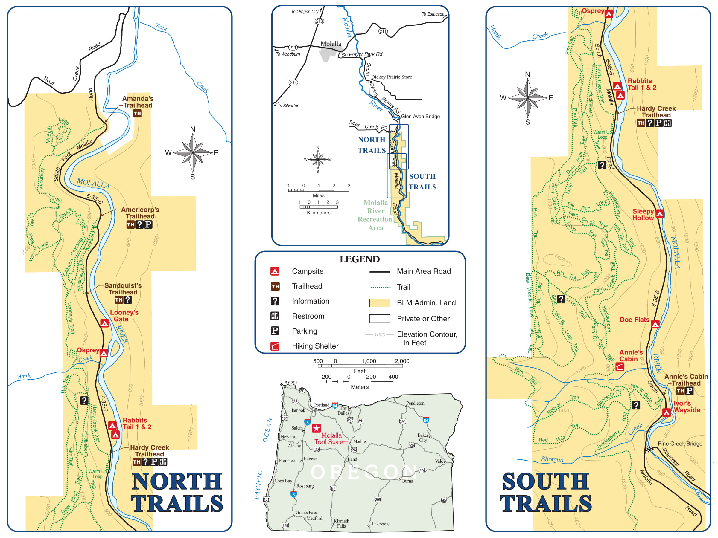
In 1992, a land exchange between the Bureau of Land Management and a private landowner placed approximately 12 miles of Molalla River frontage into public ownership. The stretch of river from Trout Creek Road to the Table Rock Wilderness is now referred to as “The Molalla Recreation Corridor”. This former site of working steam donkeys, railroads, and logging camps, today, offers year-round recreational opportunities such as hiking, bicycle riding, horseback riding, fishing, kayaking, swimming, picnicking, nature watching, and photography, in regenerating second-growth forest.
Trails
The Molalla River Trail System is an extensive network of more than 20 miles of trail for hikers, mountain bikers, and equestrians. The system combines both single track trails and old forest roads.
The trails wind through the forested foothills and slope of the Molalla River Valley, occasionally offering scenic glimpses of the forests and mountains of the Cascade Range.
The trail system offers a variety of difficulty levels for a wide range of mountain biking, hiking, and horseback riding enthusiasts. Trails are generally marked with directional signs and levels of difficulty.
The best equestrian access to the trail system is from Hardy Creek or Annie’s Cabin Trailheads where there is ample parking for horse trailers. Mountain bikers and hikers may prefer to access the trail system via Amanda’s Americorp, and Sandquist’s Trailheads [source: BLM].
Camping
Camping in the Molalla Recreation Corridor is seasonally available at Three Bears and Cedar Grove Campgrounds. These campgrounds are seasonally available for walk-in tent camping on a first-come, first-served basis. The tent campsites are equipped with a tent pad, metal fire ring, barbecue grill, and picnic table. The campgrounds also have vault toilets and river access.
At the campgrounds, fires are limited to the steel fire rings or barbecue grills provided. No firewood collection is allowed, so if you want a fire, bring your own local firewood. Remember to follow Leave No Trace Outdoor Ethics and if you pack-it in you need to pack-it out (pack out all trash).
For up to date camping information, please contact the BLM’s Northwest Oregon District Office, 503-375-5646, email BLM_OR_SA_Mail@blm.gov. Their office is located at 1717 Fabry Road, SE, Salem, OR 97306.
It’s important to know that THERE IS NO CELL PHONE SERVICE IN THE MOLALLA RECREATION CORRIDOR. Also, use caution when driving in the Molalla Recreation Corridor because log trucks frequently use the road.
Publications
2019 Annual Report (PDF).
2018 Annual Report (PDF).
2017 Annual Report (PDF).
Fall Newsletter (PDF).
Spring Newsletter (PDF).
2016 Annual Report (PDF).
Summer Newsletter (PDF).
Molalla–Pudding Rivers Celebration
OregonLive.com: Call ‘Dr. Ecosystem’: Rural Oregon M.D. makes his acreage healthier
March 2016 – Jim Holley Presents Herpetological (Amphibian and Turtle) Survey of Clackamas County
View the 2015 Clackamas County Herpetological Surveys (PDF)
OregonLive.com and the Portland Tribune…
• “Molalla Water Typing: Field Results Summary” (Final Report to Molalla River Watch, January 10, 2016 – 7 MB PDF)
• Online map-based application (View photos, and separate layers for migration barriers, water typing survey locations, and water typing classifications)
• Online photo archive (Dropbox)
• Event Flyer for the Jn. 26th presentation (PDF)
2015 Annual Report (PDF).
Fall Newsletter (PDF).
Spring Newsletter (PDF).


